Projects: ST2106.201 / CHN0250D / T031701C
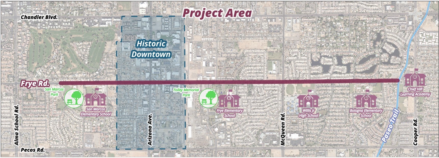
The City of Chandler is designing improvements to construct approximately 2.5 miles of protected bike lanes along Frye Road from approximately one-half mile west of Arizona Avenue to the Paseo Trail (Consolidated Canal).
The project area includes existing signalized intersection crossings at Arizona Avenue and McQueen Road, a railroad crossing, connections to five Chandler Unified School District (CUSD) schools, San Marcos Park, Folley Memorial Park, and the Paseo Trail (Consolidated Canal).
The entire length of the project is within the City of Chandler right-of-way, connecting to Salt River Project (SRP) right-of-way on the east end of the project at the Paseo Trail (Consolidated Canal).
Exhibits from Public Meeting
Objectives
Timeline
Construction Timeline
Lane Section Views: East | West
Monuments
Art Elements | Art Elements
Roll Plot - West End | Roll Plot - East End
A public meeting was held during the initial design phase on November 15, 2022, at the Chandler Downtown Library. For more information about past public meetings and displays, please contact Teresa Makinen.
Construction Information (January 20, 2026):
- Scheduled to begin this week, crews will work on the south side of Frye Road, west of Arizona Avenue to conduct removals, grade, and pour concrete as part of the construction of the raised bike lane in that area. This work is expected to be completed early to mid February.
- Crews are currently working on the east end of the project at the cul-de-sac near the Paseo Trail (Consolidated Canal). This work includes conducting removals, forming and pouring concrete, and grading to prepare the subsurface of that area for future paving. This work is expected to take several weeks to complete.
- Electric crews are also conducting work to install street light foundations on the south side of Frye Road, working from McQueen Road to the west. This work is also expected to continue into mid-February.
- Scheduled to take place the week of Jan. 26, crews will conduct removals to construct the bus stop on the south side of Frye Road at Oregon Street. Similar work will take place the week of Feb. 2 on the south side of Frye Road at Nebraska Street.
- APS crews continue work on their facilities in Frye Road west of Arizona Avenue.
To accommodate the planned work, traffic and detour signage is in place to direct travelers around the work zone, as needed. Access to residences, businesses, and schools is being maintained during this work, although it may not be the most direct route. Should access need to be restricted to provide a safe work area, the contractor will ensure alternate access is available and signage placed, as needed, to inform travelers.
Thank you for your patience during this work.

Project History
The Frye Road Protected Bike Lanes project was identified as a near-term bicycle facility recommendation in the Chandler Transportation Master Plan (TMP) 2019 Update. During the development of the TMP 2019 Update, the majority of community feedback indicated that Chandler residents are interested in bicycling but have concerns over sharing roadways with vehicles and desire a more comfortable experience that physically separates bicyclists from vehicular traffic.
The Frye Road Protected Bike Lanes Project will be the first project to design and install protected bike lanes to address these concerns, provide a more comfortable option for bicyclists, and enhance the connection and accessibility to Downtown Chandler, schools, parks, and the Paseo Trail.
Frye Road is classified as a federal functional class minor arterial in the Maricopa Association of Governments (MAG) Transportation Improvement Program (TIP). However, within the project limits, it functions as a collector street and is not shown as a minor arterial on the City of Chandler’s TMP 2019 Update Roadway Function Classification Map.
Please contact us with your questions or comments, or you can call our project hotline to speak with one of the team members.
Project Hotline: 480-898-4060
Chandler Title VI Notice to the Public
The City of Chandler hereby gives public notice that it is the City’s policy to assure full compliance with Title VI of the Civil Rights Act of 1964, the Civil Rights Restoration Act of 1987, and related statutes and regulations in all programs and activities. Title VI requires that no person shall, on the grounds of race, color, sex, national origin, age or disability be excluded from the participation in, be denied the benefits of, or be otherwise subjected to discrimination under any Federal Aid Highway program or other activity for which the City receives Federal financial assistance.
Any person, who believes his/her Title VI protection has been violated, may file a complaint. Any such complaint must be in writing and filed with the City’s Title VI Program Manager within one hundred eighty (180) days following the date of the alleged discriminatory occurrence. Title VI Discrimination complaint forms may be obtained from the City by contacting: Dan Haskins, Title VI Program Manager, Mail Stop 407, PO Box 4008, Chandler, AZ 85244-4008/ 480-782-3335 (or 711 via AZ Relay Service).


